

Table of Contents
Nuwaragala is not a campsite in the conventional sense. There are no pitches, no wash blocks, no designated fire rings. What exists is a 658-metre rock mass in the Ampara District, topped by a drip-ledged cave large enough to shelter roughly 150 people, approached by a stone-paved pathway built over two thousand years ago. Campers sleep inside that cave or on the open summit. The experience is raw, the access is regulated, and the wildlife is real.
This guide covers what the mountain is, how to reach it, what permission is required, what the hike demands, and how to camp there without creating problems for yourself or the site.
Where Is Exactly Nuwaragala Mountain?
Nuwaragala sits in Pollebedda village, within the Mahaoya Divisional Secretariat Division of Ampara District. The land falls under the Department of Forest Conservation. The mountain belongs to the Gal Oya range and rises to 658 metres above a surrounding plain of paddy fields, reservoirs and dry-zone forest.
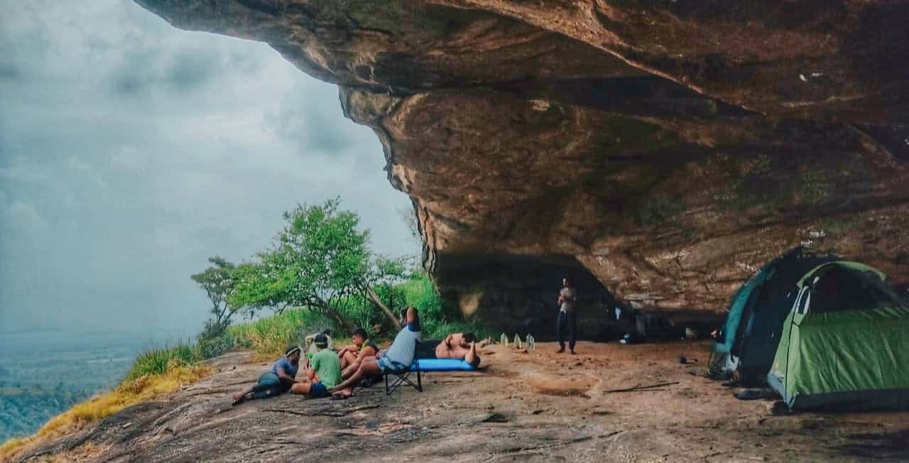
The summit holds three features that matter to campers. The first is the cave: a large drip-ledged shelter, partitioned in antiquity with brick walls, its interior once plastered and decorated. The plaster is ruined now, but the cave still offers reliable overhead cover. The second is a rock pond, roughly thirty feet across, cut into the summit. Villagers say it never runs dry, and it remains the main water source for wildlife in the area. The third is the stone pathway itself, nearly twenty feet wide in places, which climbs to the summit and links the cave, the pond and the scattered ruins of a monastery complex.
Around the summit and along the slopes, you will find stone pillars, tank walls, cave inscriptions and the remnants of a statue house. None of this has been fully researched, and the archaeological record remains incomplete.
The Historical Context Campers Should Understand
The ruins are not decorative background. They determine how you should behave on the mountain.
Scholars disagree on the site’s exact origin. One view holds that King Saddhatissa, brother of King Dutugemunu, used Nuwaragala as a hideout and fortress. Another attributes the monastery to King Lajjatissa, who ruled from 119 to 109 BC. A third identifies the site with Girinuwara, the city of Prince Giri Abaya. What is not disputed is that a monastic complex existed here by the first century BC, and that the cave, pond and pathway formed part of it.
The pond was built to serve hundreds of arhat monks in meditation. The cave housed them. The pathway connected the summit to the world below. Campers today use the same infrastructure for entirely different purposes. The practical consequence is simple: you are camping inside an active archaeological site. Do not damage the stonework, do not write on the rock, and do not remove anything.
Reaching the Trailhead
The approach to Nuwaragala begins at Maha Oya, a town on the Mahiyangane–Dimbulagala–Dalukkane Highway. From Maha Oya, you travel towards Pollebedda village and then to the foothills. The final stretch to the trailhead is roughly four kilometres by road or track, followed by a climb of two to three kilometres to the summit.
If you are coming from Colombo, the route runs through Nittambuwa, Kegalle, Mawanella, Kandy, Teldeniya, Hasalaka, Ududumbara, Mahiyanganaya, Padiyatalawa and then Maha Oya. The total distance is around 300 kilometres. Public transport is possible: a night bus from Colombo to Ampara departs at 10:45 PM and costs LKR 1,100 one way. The return bus leaves Maha Oya at 3:45 PM. Seats should be reserved a day in advance.
Most campers arrange transport to Maha Oya or Pollebedda and then continue by local vehicle or on foot. The road conditions vary, and the final approach is not suitable for all vehicles.
The Hike: Distance, Terrain and Difficulty
The trail to Nuwaragala is between 8 and 10 kilometres one way, depending on where you start counting. The climb takes roughly five to six hours. The return is faster but not easy.
The terrain includes thick jungle, steep sections, rocky ground and at least one river crossing. After heavy rain, the water can reach chest height. The trail passes through areas where elephants move regularly. You may also encounter wild boar, deer and, less commonly, bears. The path is not maintained in any formal sense. In places, it is a footpath; in others, it follows the ancient stone route.
The final approach to the summit involves a climb up the rock itself. The stone pathway helps, but the surface is uneven and worn. Hiking shoes with good grip are necessary. Sandals or trainers without tread will make the descent dangerous.
Do not attempt this hike if you are not comfortable in dense jungle, if you cannot manage several hours of sustained uphill walking, or if you are unwilling to follow a guide’s instructions without argument.
Camping on the Summit
Camping at Nuwaragala means one of two things: sleeping inside the cave, or pitching a tent on the open summit.
The cave offers shelter from rain and wind. Its floor is uneven in places, and the stone walls do not provide complete protection from insects or animals. Tents can be pitched inside the cave or on the surrounding rock. The summit is exposed, so tents need to be secured against wind. There are no facilities of any kind. You carry in everything you need and carry out everything you bring.
The pond at the summit is the only water source. It is used by wildlife. Treat any water you take from it before drinking. In practice, most campers carry all their drinking water with them.
A campfire is possible, but you should keep it small and contained. The surrounding forest is dry for much of the year, and the archaeological ruins include combustible material. Do not build a fire inside the cave or against any stone structure. Do not cut standing wood. If you cannot manage a fire safely, do not light one.
The reward for the climb is the view. From the summit, you can see the Gal Oya mountain range, Pettigala, Savula Hela, Ethbedda, Walas Mountain, and several reservoirs: Nuwaragala Tenna Wewa, Borupola Wewa, Rukam Wewa, Weligahakandiya Wewa and Rambaken Oya. At night, the absence of light pollution makes the stars unusually clear. Sunrise is the main event; the light breaks over the eastern wilderness and the reservoirs below.
Wildlife & Safety
Elephants are the primary risk. Nuwaragala sits within a known elephant corridor. The animals move through the area regularly, and encounters are possible on the trail and near the summit. In June 2025, the Sri Lanka Army and Wildlife Department conducted an operation to drive twenty-six elephants from Mivithapura towards Nuwaragala, which indicates the density of the population in the surrounding landscape.
Bears have also been reported. They are less commonly seen than elephants, but the risk is real enough that previous visitors have cited it as a reason to hire a guide.
Your behaviour around wildlife matters. Do not approach elephants. Do not block their path. If you see them at a distance, stop, stay quiet and let your guide assess the situation. Do not run. Do not camp in a location where elephants have recently passed. Your guide will know where those places are.
Other practical safety points: carry a first-aid kit, carry more water than you think you need, tell someone outside the group where you are going and when you expect to return, and carry a torch or headlamp. Mobile signal is unreliable in the jungle. Do not rely on your phone for navigation or emergency contact.
Permission, Guides & Costs
You cannot legally camp on Nuwaragala without informing the Wildlife Department and obtaining permission. The mountain sits within a jungle area where wild elephants move, and the department controls access. Contact them before you travel. Do not assume that permission will be granted automatically, and do not proceed without it.
A local guide is not legally mandatory, but it is the single most important decision you will make. The trail passes through known elephant habitat, and the route is not marked. A guide from Pollebedda or Maha Oya will know where elephants have been moving, where the river crossings are safe, and how to avoid the areas where bears have been reported. Gunawardana Aththo, an indigenous leader from the area, is one guide who has been recommended by previous visitors. His fee is LKR 1,000 per person. Other guides can be arranged through local contacts or tour operators.
There is a fee of LKR 1,250 covering the permit and related charges. If you join an organised trip, prices vary. One operator charges LKR 19,500 per person for a two-day package including transport from Colombo, meals, camping gear and a guide. That figure is not a baseline; it reflects a fully supported trip. Independent campers who bring their own equipment and arrange their own transport will spend considerably less.
What to Bring?
The following list reflects what the terrain and conditions actually require. It is not a generic camping checklist.
- Tent: A freestanding tent is easier to pitch on the rock surface. If you plan to sleep in the cave, a tent is still useful for insect protection.
- Sleeping bag: Nights at 658 metres in the dry zone are not cold by highland standards, but they are cooler than the surrounding plain. A light bag is sufficient for most of the year.
- Hiking shoes: Grippy soles are essential for the rock sections, especially on the descent.
- Water: Carry at least two litres per person for the hike, plus additional water for cooking and drinking at camp.
- Food: There are no shops or stalls on the mountain. Bring all meals and snacks.
- Cooking equipment: A small stove is preferable to an open fire. Fuel must be carried in.
- Torch or headlamp: Essential for moving around camp after dark.
- Insect repellent: The jungle is thick with mosquitoes and leeches, particularly after rain.
- First-aid kit: Include blister treatment, antiseptic and any personal medication.
- Rubbish bags: You must carry out everything you carry in. There is no waste collection.
- Clothes: Lightweight, long-sleeved clothing for the hike protects against scratches and insects. Bring a change of clothes for camp.
- Rain protection: Even in the dry season, rain is possible. A lightweight tarp or rain jacket is useful.
Best Time to Visit
The recommended window is February to September. This corresponds to the drier months in the eastern dry zone. The trail is less muddy, the river crossings are lower, and the risk of leeches is reduced.
The northeast monsoon brings rain to the eastern side of the island from roughly October to January. During this period, the trail becomes slippery, the river can rise to chest height, and the summit is frequently cloud-covered. Camping is still possible, but the margin for error narrows considerably.
Even within the recommended window, conditions can change. Check the weather before you travel, and ask your guide about current trail conditions.